
Summer is peak travel season across the West, which can mean fully booked hotels, endlessly long lines at national parks, and so much traffic. These seven areas—from Arizona’s White Mountains to Oregon’s McKenzie River—are off well-trodden routes so you can explore and relax in peace.
California Gold Country
Two-lane Highway 49 runs through the Sierra Nevada foothills’ pine, cedar, and oak forests and historic mining towns that drew tens-of-thousands of fortune-seekers in the mid-19th century. From Coloma south to Columbia State Park is an 80-mile stretch dotted with wineries and walkable downtowns that look as though they’re straight out of an Old West film.
Spend an afternoon browsing the many antique and collectible shops in Placerville, Sutter Creek, Jackson, and Angels Camp. Get your feet wet panning for gold in the American River at Coloma’s Marshall Gold Discovery State Historic Park. Don’t miss Columbia State Historic Park, where costumed docents detail what life was like in this meticulously preserved Gold Rush town while serving up sarsaparilla sodas in a Western-style salon and offering stagecoach rides on weekends.
If you want to extend your stay, lodging is plentiful up and down the route, as are good eats. Try Jackson’s Brickhouse Brews for juicy burgers, or pick up a charcuterie plate and other picnic goodies at the Sutter Creek Cheese Shoppe.
Arizona's White Mountains
Sneak away to northern Arizona’s high-country, where small towns like Show Low (about 180 miles from Phoenix), Pinetop-Lakeside, and Greer sit among tranquil lakes and stands of ponderosa pine. Much of the area is White Mountain Apache Lands, which you can learn about at the White Mountain Apache Cultural Center and Museum in Fort Apache Historic Park.
Whether it’s horseback riding through forests at Porter Mountain Stables, just outside Pinetop-Lakeside, or trekking the 14-mile out-and-back West Baldy Trail up the side of 11,409-foot-tall Mount Baldy, the highest point in Apache country, this road-trip supplies plenty of outdoor adventure. Take a dip in the waters of Fool Hollow Lake Recreation Area, or camp in the ample shade of its juniper and pinyon pine trees.
Step inside the historic digs of Greer’s Butterfly Lodge Museum, a more than 100-year-old cabin that housed both the adventure author James W. Schultz and his son, American Indian painter Hart M. Schultz (aka Lone Wolf).
Once you’ve worked up an appetite, bite into the fried jalapeno-topped cheeseburgers at Mr. Zeke’s Restaurant in Pinetop-Lakeside, or enjoy pulled pork, prime rib sandwiches, and the casual al fresco seating at Show Low’s the House.
Oregon’s McKenzie River
Follow the clear blue water on the McKenzie Pass-Santiam Pass Scenic Byway (Oregon Route 126) from the state’s fertile Willamette Valley to its spectacular Cascade Mountains. The 60-mile stretch links several riverside communities and has a plethora of activities to choose from.
Known for its waterfowl, including herons and grebes, Walterville is also home base for the McKenzie River Guides Association, a consortium of dozens of licensed and insured guides who offer everything from trout fishing trips to whitewater rafting on the river’s Class III rapids.
If it’s pick-your-own fruit you’re after, Leaburg’s Blueberry Patch Farm is the place to go (check hours before arriving). In nearby Vida you’ll find Oregon’s second-longest covered bridge, a 165-foot-long white-painted beaut featuring a series of arched louvered windows.
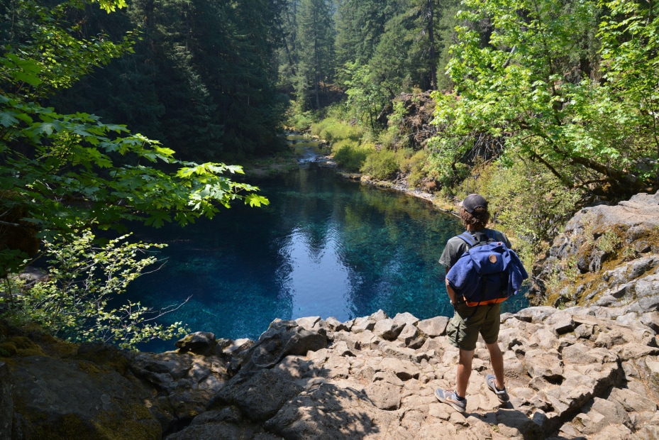
Head deeper into the wilderness with a hike on part of the McKenzie River Trail, a 26-mile trek with 11 trailheads along Highway 126 that happens upon lava fields, old-growth trees, and an almost iridescent blue pool of water at the base of the seasonal Tamolitch Falls. Or opt for a relaxing soak in soothing mineral pools at Belknap Hot Springs, six miles west of the town of McKenzie Bridge.
For an overnight stay, choose from B&B-style lodges, creekside cabins, and the riverside Paradise Campground tucked within Willamette National Forest.
Cheyenne to Devils Tower, Wyoming
It’s a roughly 300-mile drive from Wyoming’s capital city to Devils Tower National Monument in the timbered mountains of Black Hills National Forest, and there’s plenty to see and do along the way, which makes it ideal for a multi-day trip.
Heading north from Cheyenne, stop at Fort Laramie National Historic Site, a former private fur trading fort established in 1834 that later evolved into a Frontier army post. Learn about its role in American Indian history and Western Expansion while touring 12 restored buildings, including an old bakery and a guardhouse. Nearby are the Guernsey Ruts, some five-foot-deep, that remain from wagons passing during the Oregon Trail’s heyday.
East of Devils Tower is Vore Buffalo Jump, a natural sinkhole that American Indians used as a trap for bison as far back as 1500 A.D. During the summer, the site is open to visitors who’d like to learn about the more than 20 layers of bones and artifacts that have been excavated here, along with stories of the Plains Indians, the region’s original residents.
The pinnacle of the trip is Devils Tower, a butte of igneous rock rising 1,267-feet above the Belle Fourche River. Sidestep the crowds on the popular Tower Trail and hike the 2.8-mile Red Beds loop instead. Finally, spread out your blanket (or table cloth) at the Devils Tower picnic area.
Utah’s Monument Valley
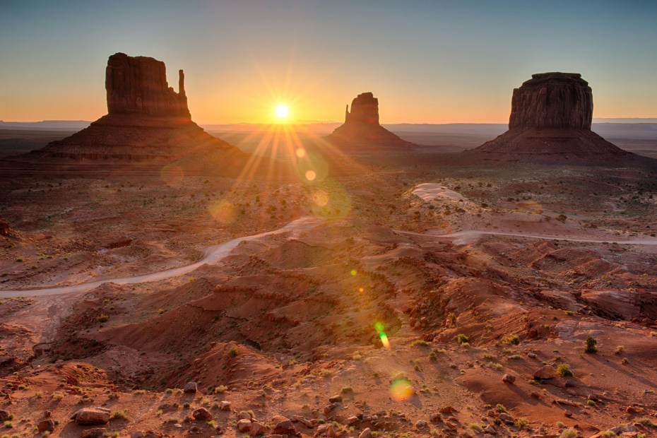
A 283-mile drive east from Utah’s St. George Regional Airport sits one of the most mind-blowing landscapes imaginable: Monument Valley, where deep red monoliths and spire-like buttes ascend upwards from the desert in extraordinary formations, some topping 1,000 feet.
Located along the border of southeast Utah and northeast Arizona, Monument Valley Navajo Tribal Park is a part of the Navajo Nation. An $8/person fee provides access to the park and its otherworldly sites, which are best viewed along the 17-mile-long Valley Drive. This scenic loop is perfect for soaking in some of the region’s most remarkable large-scale landscapes, from the Three Sisters—a trio of narrow spires—to John Ford's Point, a favorite promontory that the famed director often used in his Hollywood Westerns.
At the Monument Valley Navajo Nation Welcome Center, book excursions with certified Navajo tour operators to areas in the valley that are otherwise off limits, such as Ear of the Wind—an impressive natural arch eroded in DeChelly sandstone. Just adjacent sits The View Hotel, an authentic Navajo gem overlooking the valley. The lodging’s Trading Post sells everything from hand-woven baskets to John Wayne memorabilia.
Montana’s Billings and the Beartooth Highway
Montana’s largest city is brimming with history, not to mention loads of outdoor fun and a nearby “All American Road” to boot. Delve into the past of the Yellowstone River Valley at the Western Heritage Center where you can hear oral histories from members of local Crow and Northern Cheyenne tribes and sit in a replica lobby of a 1930s dude ranch lodge. A 10-minute stroll away, contemporary art, including the abstract landscape paintings of Montana Modernist Bill Stockton, is on display at the Yellowstone Art Museum.
For superb views of the Billings Valley, hike the area’s sandstone formations known as Rimrocks along the 1.7-mile Four Dances Rim Loop. Afterwards, check out the ancient cave paintings of Pictograph Cave State Park, once home to generations of prehistoric hunters.
Though it is a windy road and traffic moves slowly, the breathtaking Beartooth Highway (which runs from Red Lodge, about an hour’s drive southwest from Billings, to Yellowstone’s northeast entrance) is worth the extra time. This 69-mile stunner rises to 10,947 feet, zigzagging among lodgepole pine forests and glacially carved valleys with jaw-dropping vistas around seemingly every turn.
Valdez, Alaska
An ideal road-trip destination from both Anchorage (305-miles) and Fairbanks (364-miles), Valdez stands perched on the north shore of the 13-mile long Port Valdez fjord. It’s a gateway to Prince William Sound and is situated among the towering Chugach Mountains where you can hike, alpine camp, and watch wildlife (think eagles, moose, and black and brown bears).
Kayak calm inlets where humpback whales and horned puffins reside and glacier lakes filled with floating icebergs. For more glacier views there’s the 5.3-mile out-and-back Shoup Bay Trail, which skirts Port Valdez and meanders through a forest of spruce and alder trees
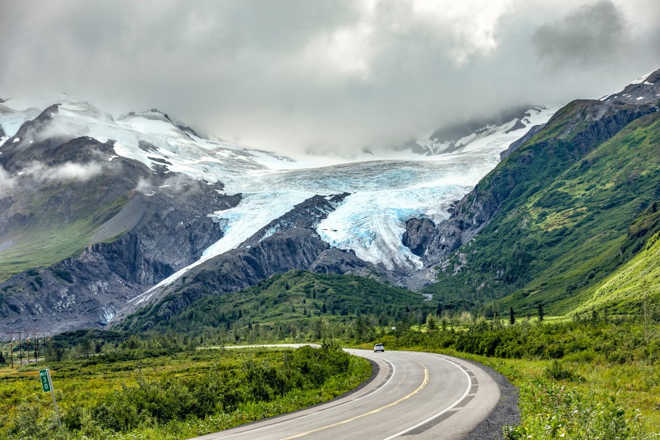
Drive out to Columbia Glacier, the second-largest tidewater glacier in North America, or take to the two-lane, 2,678-foot high Thompson Pass, an astounding stretch of roadway smack in the middle of mountain peaks, flowing streams, and gushing waterfalls.
Back in town, learn about the aftermath of the 1964 Good Friday Earthquake, which destroyed Old Town Valdez (located four miles west), and the Trans-Alaska Pipeline System, including the infamous 1989 Exxon Valdez Oil Spill, at the Valdez Museum.