
Forty years ago, the Pacific Northwest and the rest of the world received a loud reminder: Volcanoes can be as powerful as they are beautiful. On May 18, 1980, Washington's Mount St. Helens—a gleaming, symmetrical peak that sparkled with glaciers and snowfields above slopes of timeless old-growth forest—violently exploded and partially collapsed in a plume of ash, rock, and searing heat that jolted an entire region and forever changed the landscape.
Mount St. Helens still stands, a stark, brooding summit that lost 1,300 feet of its height but none of its wonder. Puffs of steam still occasionally waft from its two-mile-wide crater, now home to one of the world's newest glaciers. Volcanoes reinvent and rebuild themselves, seemingly on an endless mission to combine rocks, ice, and heat into massive works of natural splendor. From California to Alaska, the West is home to more than 114 active volcanoes, all stunning monuments to the creative forces of geology. Easily accessible by car and foot, these majestic marvels make for an ideal road trip, as do the charming towns that surround them.
"Volcanic landscapes are some of the most dramatic and breathtaking on this planet," says Elizabeth Westby, a geologist with the Cascades Volcano Observatory in Washington. "They make you feel humble and grateful at the same time."
Throughout the West, visitors are drawn to the views, trails, and adventures that surround volcanic peaks. Major eruptions are rare, and it's very unlikely that your volcano adventure will turn explosive, but it's still smart to stay informed. The U.S. Geological Survey posts updates and warnings for all the volcanoes in the Cascade Range on its website.
Here are some of the best places in the West to take a volcano vacation.
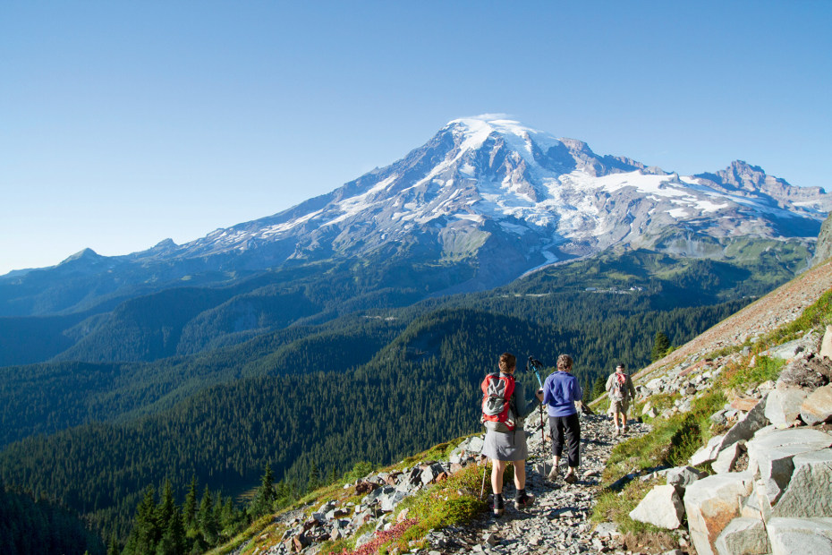
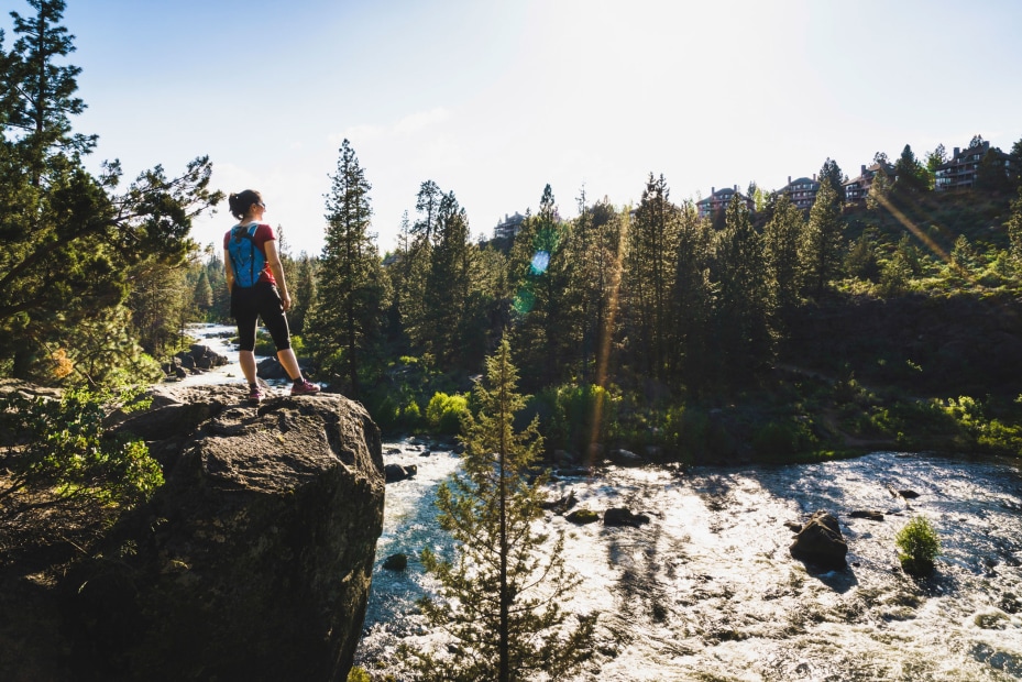
Backpackers gather near Pinnacle Peak.
Mount Rainier, Washington
Seattleites have a simple method for gauging their weather: If Mount Rainier is in sight, it's a nice day. The view only improves the closer you get to the mountain, the tallest volcano in the Cascade Range. Snowfields and more than 20 glaciers gleam on the upper reaches, masking the heat that still roils inside. Rainier's last major eruption was about 2,200 years ago, but geologists are watching the mountain minute by minute, day by day for signs that another blast may be on the way. So far, so good.

An old-school burger shack, Scaleburgers in Elbe feeds hungry hikers.
Rainier's heavily forested foothills hide several small towns that largely owe their lives to the mountain. Next to Alder Lake just west of Mount Rainier National Park, vintage steam locomotives chug from Elbe to the Mt. Rainier Railroad and Logging Museum in Mineral, a 30-minute trip that passes over the turquoise upper Nisqually River and through a forest of hemlock and cedar. Back in Elbe, you can pick up a raft of burgers and shakes from Scaleburgers for a satisfying picnic dinner with a view. The view might change with the weather, but the mountain stays constant.
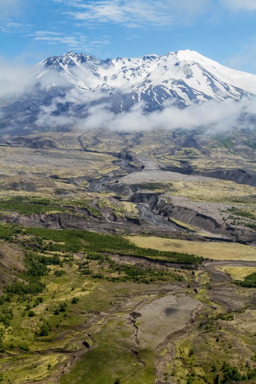
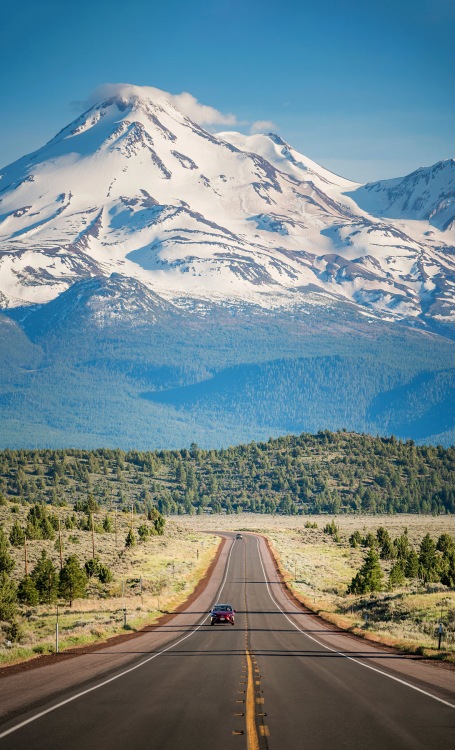
Snowcapped Mount St. Helens dominates the surrounding terrain.
Mount St. Helens, Washington
Forty years after the eruption, memories and scars feel fresh. Drive to the Johnston Ridge Observatory viewpoint, just five miles from the crater, and you'll be in the heart of the blast zone, where fallen trees lie like signposts pointing away from the explosion. The classic cone-shaped peak is now a horseshoe-shaped crater. From this view, it's easy to imagine the moment when the north side collapsed. After pondering that history, you can immerse yourself in the present life of the mountain with a short hike down the Boundary Trail, where lupine, Indian paintbrush, and other signs of life have slowly invaded a land of ash and pumice.

Refuel on locally roasted coffee at Vault Books & Brew.
The towns near St. Helens survived and thrived. Castle Rock, Washington, a 50-mile drive west from Johnston Ridge, packs a lot of activities into a small town. You can head downtown for a cup of locally roasted coffee and a good read at Vault Books & Brew. The Mount St. Helens Visitor Center on Spirit Lake Memorial Highway just outside Castle Rock showcases the mountain with huge viewing windows and a step-in model of a volcano. Take the short boardwalk trail through duck-filled wetlands and you'll get some fresh views of St. Helens, a mountain with an amazing past and uncertain future.
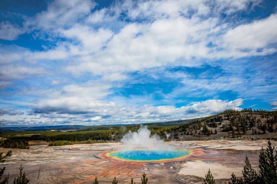
Yellowstone's Grand Prismatic Spring glows in otherworldly rainbow colors.
Yellowstone Caldera, Wyoming
There are volcanoes, and then there are supervolcanoes, places that push the concept to the extreme. Yellowstone National Park boasts a crater (geologists call it a caldera) that's 45 miles wide, encompassing Old Faithful geyser, the Yellowstone waterfalls, and most of Yellowstone Lake. The supervolcano erupted 640,000 years ago in a cataclysmic blast that released 2,400 times more ash and rock than the recent St. Helens explosion. Disaster movies and alarmist Internet rumors aside, geologists say there's no sign that Yellowstone will erupt again anytime soon.
That's good news for the cities outside the park, including Cody, Wyoming, 50 miles east. A true Western town overlooking the Shoshone River, Cody is home to the Buffalo Bill Center of the West, a day-filling five museums in one. Cowboy paintings by C.M. Russell and posters advertising Buffalo Bill's Wild West show celebrate Western history, while geology displays and a video about the Yellowstone Caldera remind visitors what the area is all about: underground forces creating a magical world above.
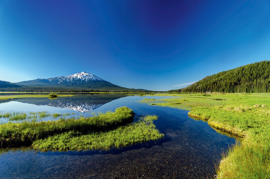
Mount Bachelor's image reflects in Sparks Lake.
Mount Bachelor, Oregon
Standing alone in central Oregon—hence the name bachelor—this dormant cone-shaped volcano is both a destination and, for many skiers and hikers, a way of life. Drive the Cascade Lakes National Scenic Byway from Bend, and Mount Bachelor will soon appear in its full glory. On most days, you'll also see the Three Sisters, a nearly-identical trio of volcanic peaks that keep Mount Bachelor company to the northwest. On Bachelor, the same chairlifts that carry winter skiers up the slopes deliver sightseers from the West Village at 6,300 feet to the Pine Marten Lodge at 7,800 feet. Hard-core hikers go on to bag the summit 2,600 feet above, but Scapolo's Bistro inside the lodge offers mountain views (as well as burgers and pizza) without the effort.
The 12-mile Deschutes River Trail runs through the center of Bend.
Bachelor provides a dramatic backdrop to Bend, a city that runs on the outdoors. Here, the main thoroughfare is the Deschutes River, a favorite spot for rafting and fly-fishing. With miles of walking and biking trails in town, it's easy to work up an appetite and thirst for Bend's restaurants and microbreweries. Cover your bases with a bowl of beer cheese soup at the Deschutes Brewery. Like the famous volcano nearby, Bend stands apart.
The easy, 1.7-mile Round Top Loop Trail delivers scenic vistas.
Sibley Volcanic Regional Preserve, California
The tectonic forces that rattle the San Francisco Bay Area with earthquakes have also built some beautiful landscapes, including a 10-million-year-old extinct volcano in the hills above the East Bay. The volcano itself has folded and twisted over that time, but ancient lava flows and clumps of ash that have hardened into rock tell the unmistakable story of the geologic past. Trail brochures at the unstaffed visitor center on Skyline Boulevard describe the rock formations and points of interest. Take a short hike to the tip of Round Top peak (elevation 1,763 feet) for a volcano-top view of the bay.

Grab a loaf of sourdough bread at Berkeley's Cheese Board Collective.
The volcanic preserve shares the East Bay hills with other gems such as Tilden Regional Park, a 2,000-acre sanctuary where visitors of all ages traverse the hiking trails and take spins on a hand-carved carousel. The park's botanic garden brims with native California flora, including live oak, redwood, and manzanita, a hardy tree of the chaparral biome. In July, blooms of red and yellow penstemons bring in crowds of hummingbirds. Happy pigs, sheep, and chickens greet guests to Tilden's Little Farm. A pizza from the Cheese Board Collective in nearby Berkeley would make a great topper to the day.
Highway 97 loops around Mount Shasta.
Mount Shasta, California
Rising more than 10,000 feet above rolling forest land, this massive, currently dormant volcano looms over large swaths of Northern California. However you approach, you'll feel pulled to the mountain for a closer look. The Old Ski Bowl Trail, a popular and well-maintained walkway at the end of Everitt Memorial Highway on the south side of the mountain, offers a volcanic rockscape and panoramic views of the peak and the surrounding flatlands. The highway also passes the trail to Panther Meadows, an easy walk through lively expanses of mountain grasses fed by rushing streams.

Yaks serves a popular vegetarian breakfast burrito.
The mountain towers over the scenic and serene town of Mount Shasta, where hikers and climbers plan their next adventure and photographers capture the never-grow-old sights of the mountain soaring above nearby Lake Siskiyou. The three-mile round-trip Spring Hill Trail gently climbs above town for more views of the mountain. At Mount Shasta City Park, fern- and willow-lined trails lead to a natural spring that forms the headwaters of the eventually mighty Sacramento River. After all that walking, grab a bite at Yaks, a local favorite famous for its pastries, house-roasted coffee, and vegetarian fare.
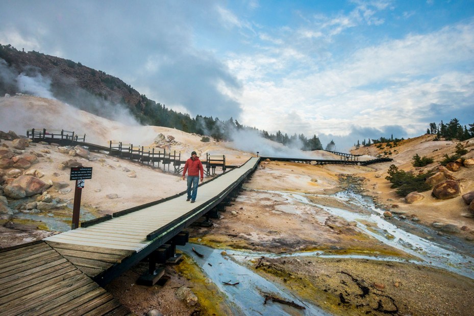
Watch the steam rise at Bumpass Hell, the largest hydrothermal area in Lassen Volcanic National Park.
Lassen Peak, California
The centerpiece of Lassen Volcanic National Park is a massive dome of lava—one of the largest such geologic wonders on earth. The underground chambers of magma that created the peak are still keeping it active. Walk the easy 1.5-mile Bumpass Hell Trail, and you'll pass through an otherworldly basin of hot pools and steam vents that fill the air with hints of sulfur. The largest vent, dubbed Big Boiler, gurgles and roars like an engine straining to move an old train. The shores of Manzanita Lake in the park's northwest corner offer a reflective and highly photogenic view of Lassen and the rugged Chaos Crags volcanoes nearby. Pictures in the small lakeside museum document a major Lassen eruption in 1914.
A half-hour drive south along a stretch of the Volcanic Legacy Scenic Byway connects the national park to Chester, a mountain community on the shore of Lake Almanor. The 75-square-mile reservoir hosts kayaks, tubes, and fishing boats on the hunt for king salmon, rainbow trout, and smallmouth bass. The Collins Pine Museum, open until mid-October, is home to a beautifully reconstructed replica sawmill that shows off the historic importance of local lumber.